Published on 12/October/2026 · Environment
Burgundy’s vineyards stay in place. Their climate does not.
By SORAH Editorial
Will a celebrated vineyard keep the climate that helped make its name? Hold today’s Côte de Beaune boundaries in place and compare growing-season temperatures across the slopes and hills behind them.
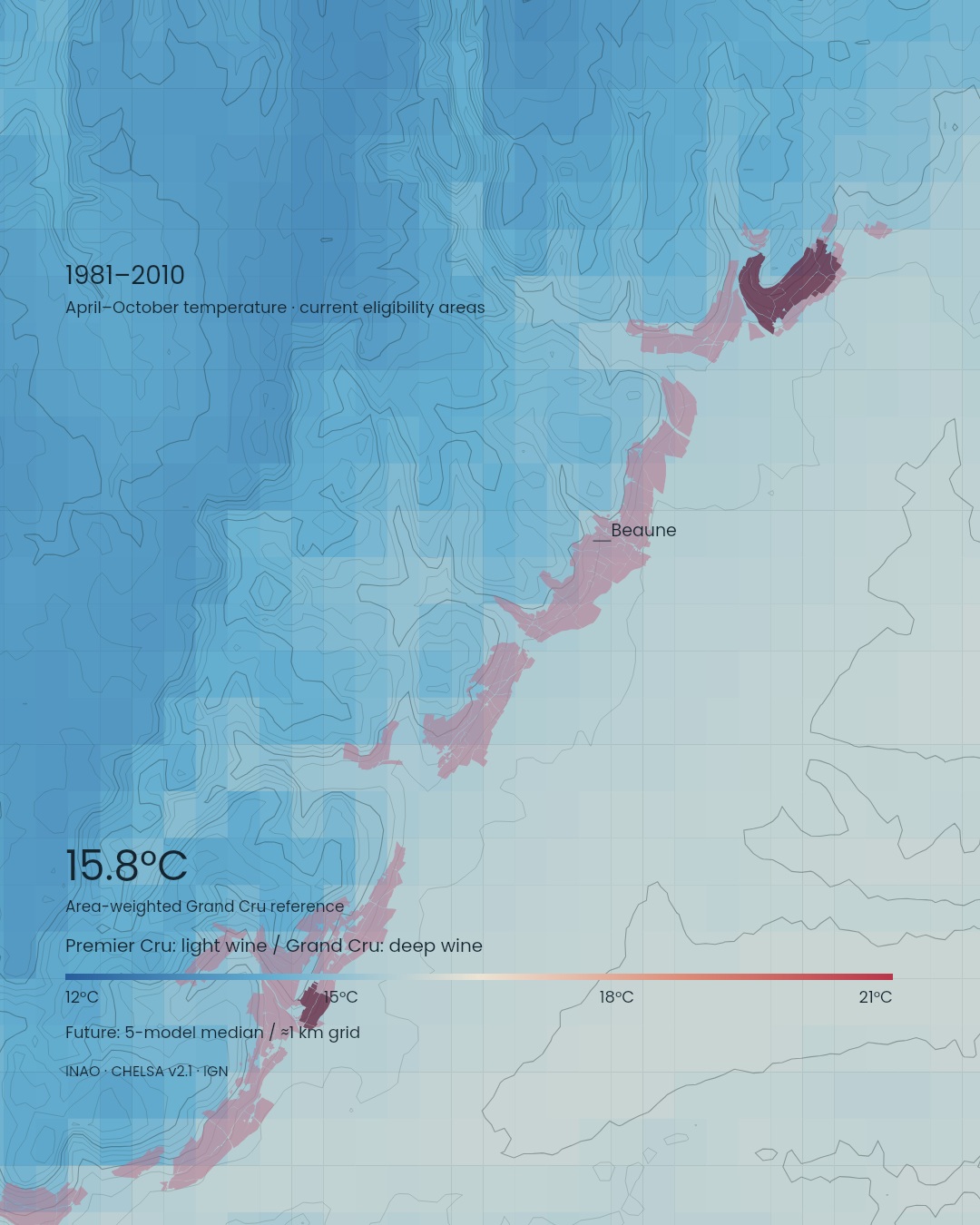
Will a celebrated vineyard keep the climate that helped make its name? Hold today’s Côte de Beaune boundaries in place and compare growing-season temperatures across the slopes and hills behind them.
A place name carried in a bottle
Beaune, Meursault, Corton, Montrachet: in Burgundy, eastern France, the name of a wine can lead back to the name of a place. Paths and stone walls turn the boundaries on a vineyard map into a landscape that can be walked.Here, a climat means a named vineyard area shaped by the recognition of differences in land and cultivation. The UNESCO property inscribed in 2015 includes 1,247 climats across the Côte de Nuits and Côte de Beaune. UNESCO
This close attachment to place gives climate change a particular meaning. If a vineyard keeps its position and its name while its growing conditions change, what can growers carry forward, and what will they need to reconsider?
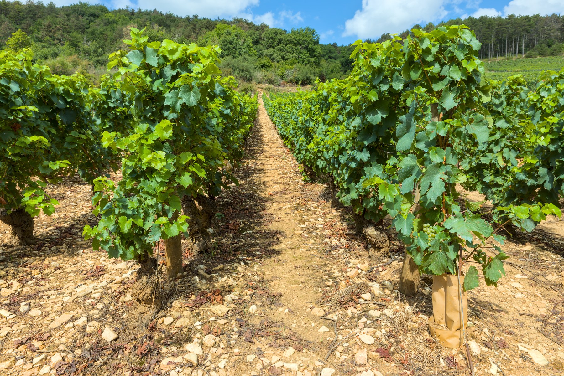
Vineyards southwest of Meursault’s town centre, France. Photographed on 3 August 2025.
The same vineyards, two possible futures
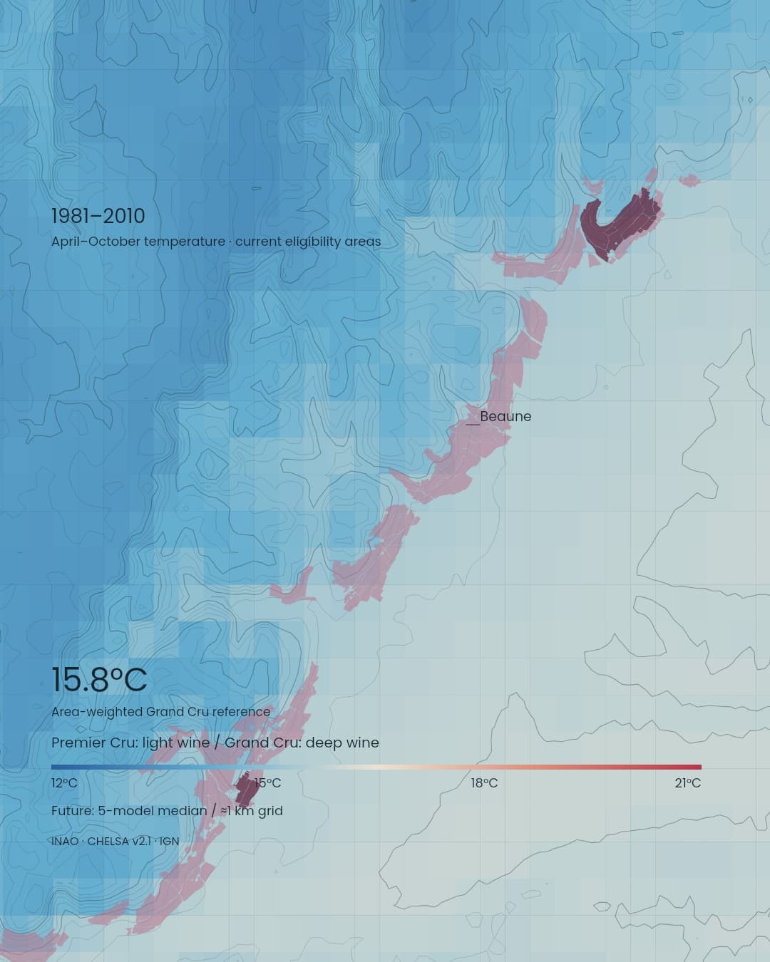
Our map focuses on the Côte de Beaune and the hills behind it. Present-day production-eligibility boundaries remain fixed while April–October mean temperatures change between 1981–2010 and 2041–2070. Light wine marks current Premier Cru eligibility areas, and deep wine marks Grand Cru areas.Area-weighting the climate cells over today’s Grand Cru eligibility areas within this extent gives a baseline of about 15.8°C. The median of five models reaches about 17.6°C under low-emissions SSP1–2.6 and 18.3°C under high-emissions SSP3–7.0. The respective model ranges are 17.4–18.6°C and 18.0–19.9°C. SORAH aggregation of CHELSA v2.1
The comparison uses 30-year conditions on climate grids roughly 1 km across. Vineyards within the same cell share its temperature estimate, linking their fixed locations with changes in the surrounding climate.
A changing harvest calendar
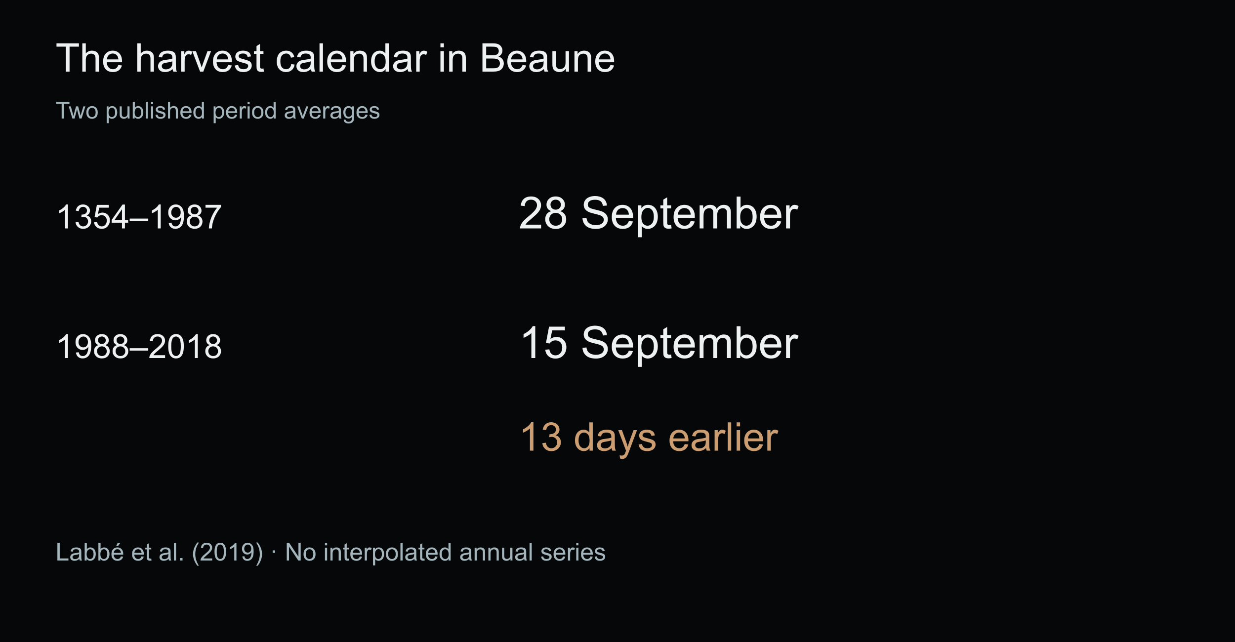
The past offers another perspective. In the Beaune harvest-date series assembled by Labbé and colleagues, the average was 28 September during 1354–1987 and 15 September during 1988–2018—a 13-day advance. Labbé et al. (2019)Harvest dates reflect fruit maturity, growers’ decisions and institutional history. Long records from the same place connect seasonal change to the calendar of agricultural work.
A 2024 review presented by INRAE describes how warming advances ripening and affects acidity, sugar and aroma across wine regions, alongside possibilities for adaptation. In the Côte de Beaune, temperature changes over existing vineyards provide a starting point for considering future cultivation choices in place. INRAE research review
From temperature to the conditions of a place
An alternative view fixes the central 80% of the baseline Grand Cru reference’s temperature distribution, about 15.55–16.04°C. Looking for that historical range in future periods reveals how its location changes across the landscape.Temperature works alongside slope, soil depth, water storage, grape variety and cultivation to shape a wine. The reference band helps locate similar temperature conditions; examining each place’s own characteristics can then guide a closer assessment of cultivation possibilities.
April–October precipitation over the same reference is about 509 mm in the baseline, with future model medians of about 479 mm and 468 mm. Studying rainfall timing and the water retained around roots alongside these seasonal totals can deepen the picture of growing conditions. Regional temperature and precipitation aggregation
Inheriting a place means making choices
France’s LACCAVE research partnership examined adaptation options including soil conservation and choices of planting material. Such decisions involve growers, researchers and the institutions that govern wine regions. INRAE: LACCAVEThe question raised by Burgundy’s celebrated vineyards extends to renowned wine regions around the world. When the next generation speaks the same regional names, what seasons—and what cultivation practices—will those names contain? Carrying forward the flavours and cultures rooted in each place means considering climate change and growers’ choices alongside its own natural environment and history.
Data and representation
Areas: INAO Délimitation Parcellaire des AOC Viticoles from official Géoplateforme WFS, accessed 12 October 2026. 16,698 records checked before selecting Côte de Beaune production-eligibility areas. Assessing planted coverage requires separate field information; official INAO plans determine legal boundaries. Open Licence 2.0.Overlaps are resolved in favour of the higher qualification. Boundaries at retrieval are fixed for comparison, with about 2m geometry simplification. Premier Cru uses light wine and Grand Cru deep wine, translucent over the temperature background with outlines. Place names are text; callouts connect to points inside eligibility areas. Fine parcel lines, regional/village fills and rivers are hidden.
Climate: CHELSA v2.1, 30 arcseconds (roughly 1km), CC0. Baseline 1981–2010; future 2041–2070 under SSP1–2.6 / SSP3–7.0. Five models: GFDL-ESM4, IPSL-CM6A-LR, MPI-ESM1-2-HR, MRI-ESM2-0, UKESM1-0-LL. April–October monthly temperatures are weighted by month length; precipitation is summed. Conversions: temperature raw×0.1−273.15; precipitation raw×0.1. Regional values in all 154 files validated.
Future maps use cellwise five-model medians. Grand Cru figures first area-weight each model over 13 intersecting cells, then calculate the median, minimum and maximum. The model range is the minimum–maximum of these five models. Simplified reference area: about 1.931km². Temperature resolution follows the roughly 1km grid.
The reference band fixes the area-weighted baseline 10th–90th percentiles at 15.551–16.037°C, then selects future cellwise medians in that interval. Its scope is similarity in April–October mean temperature. Assessments of cultivation suitability, quality or classification, and analysis of frost, heat extremes or harvest dates require additional criteria and data.
Terrain: 43,200 IGN RGE ALTI service samples at roughly 190×278m spacing. Contours every 25m are derived from those samples; geographic detail follows this sampling interval. Open Licence 2.0. All layers share coordinates and extent. Natural Earth supplies the France locator.
Harvest dates: two period averages published by Labbé et al. (2019), covering the historical periods 1354–1987 and 1988–2018.
Vineyards southwest of Meursault’s town centre, France. Photographed on 3 August 2025. Benjamin Smith / Wikimedia Commons · CC BY-SA 4.0 · Source. Proportional resizing and JPEG compression only.
Sources
- INAO · 地理情報 / geographical data
- INAO · 生産資格区域 / parcel eligibility dataset
- CHELSA v2.1 · climatologies
- CHELSA v2.1 · DOI
- IGN · RGE ALTI
- Labbé et al.2019 · Beaune harvest dates
- UNESCO · Climats of Burgundy
- 地域集計と方法 / reference aggregation
- INRAE / van Leeuwen et al.2024 · climate and wine
- INRAE · LACCAVE
Author
SORAH Editorial
October 12, 2026