Published on 02/October/2026 · Climate
Greenland in a time of change: ice and geopolitics
By SORAH Editorial
On September 22, 2026, the United States, Greenland and Denmark signed an Arctic and North Atlantic security agreement. Thirty-two annual maps show how the ice surface changed against a 1992 baseline.
On September 22, 2026, the United States, Greenland and Denmark signed an Arctic and North Atlantic security agreement. On this closely watched island, 32 annual maps show how the ice surface has changed against a 1992 baseline.
Signed at UN Headquarters in New York, the agreement strengthens defence and security in the Arctic and North Atlantic. Denmark’s Prime Minister’s Office also emphasizes the Kingdom’s sovereignty and territorial integrity and the Greenlandic people’s right to self-determination. Signature does not itself mean entry into force: the announcement makes this subject to the necessary national parliamentary procedures.[10]
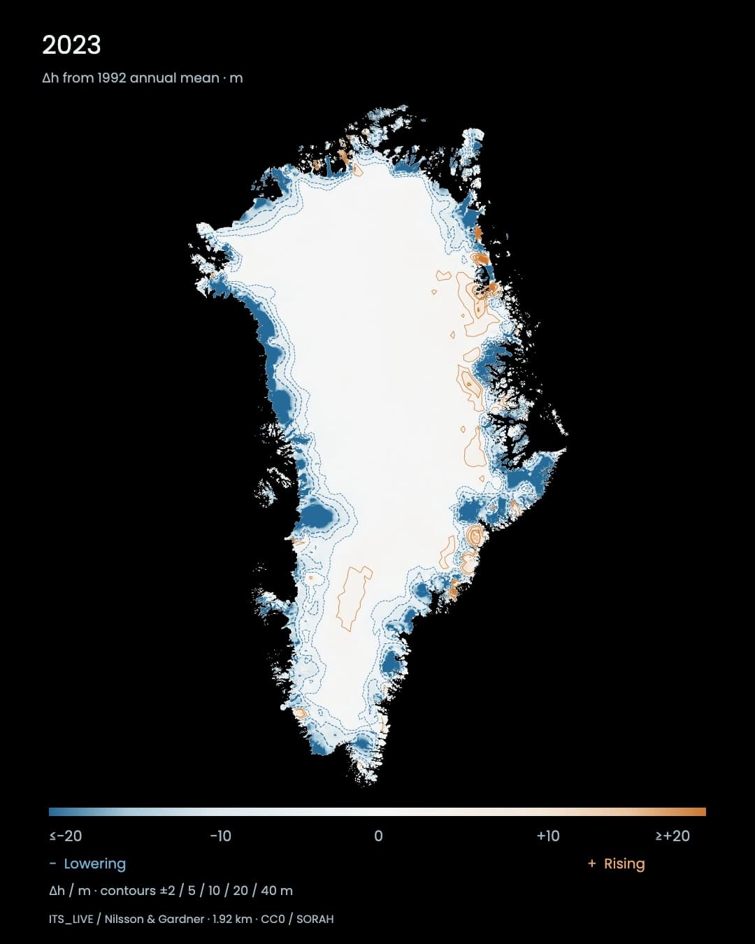
Set 1992 as the white baseline, then move forward through the years. Blue contours gather along parts of Greenland’s ice margins, while orange contours appear elsewhere. By 2023, the contrast between a relatively unchanged interior and substantial lowering in some coastal areas makes one thing clear: the surface is not changing uniformly.[1][2]
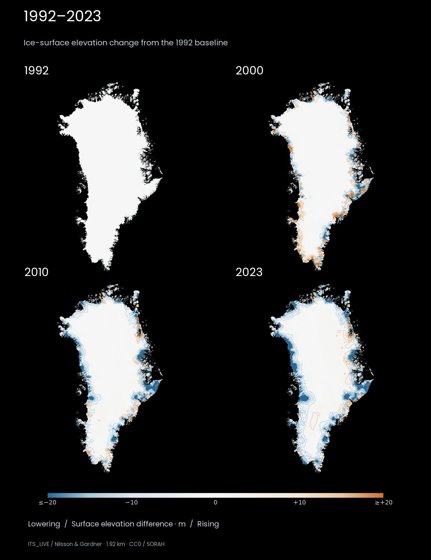
1992, 2000, 2010 and 2023 share one map extent and colour scale. Every panel is relative to the 1992 annual mean, not the preceding panel. Blue indicates lowering and orange rising; colours saturate at ±20 m.[1][2]
Greenland is both a place to observe climate change and a focus of international interest in security and resources. Understanding that interest requires looking at the island’s location as well as its changing ice.
Between the Arctic Ocean and the North Atlantic
Greenland lies between North America and Europe, facing both the Arctic Ocean and the North Atlantic. Its position has a long strategic history. In the island’s northwest, the US military’s Pituffik Space Base supports missile early warning and space surveillance. The apparently remote island is part of a wider defence network.[5]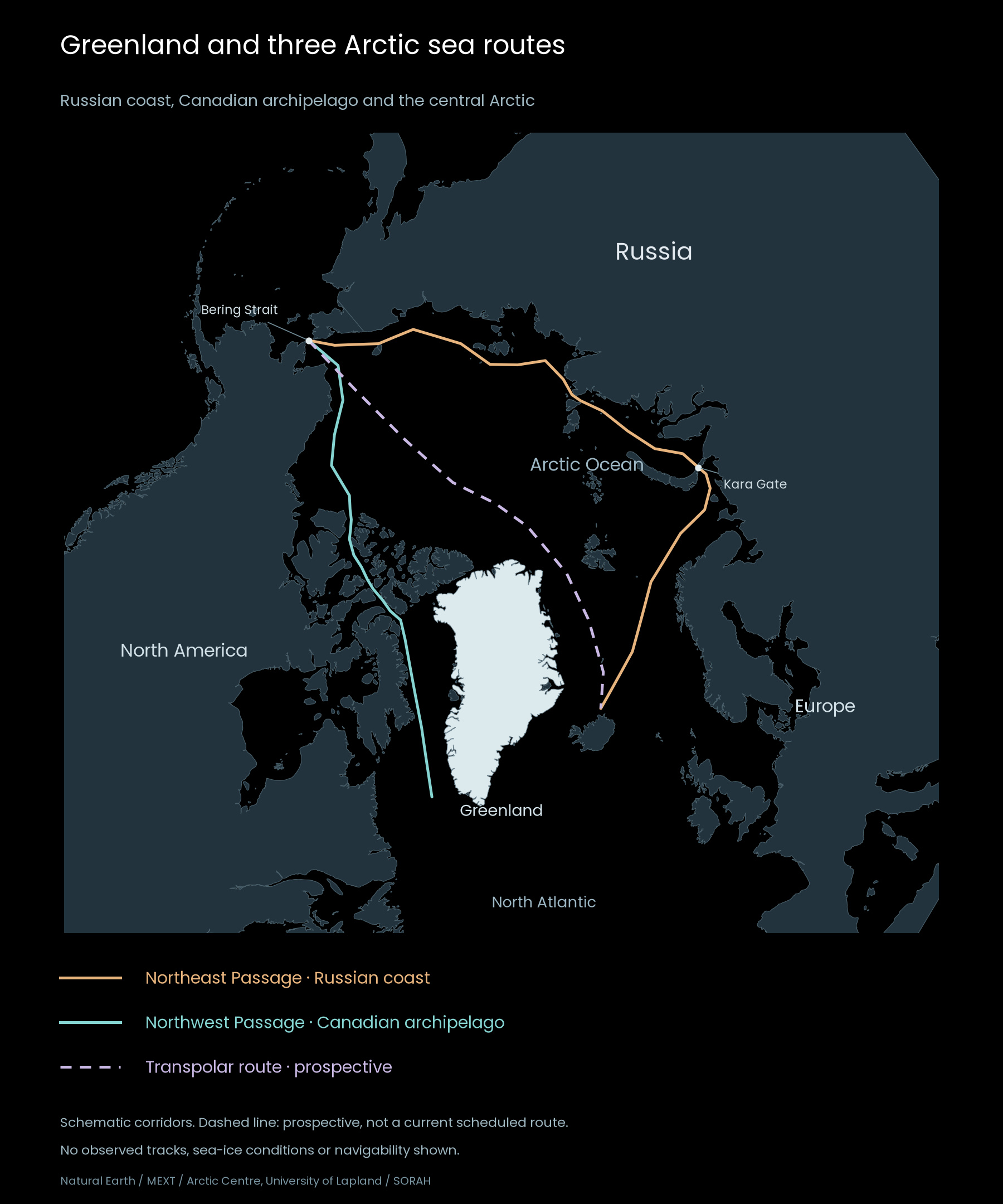
Orange: Northeast Passage. Teal: Northwest Passage through the Canadian archipelago. Dashed purple: prospective Transpolar route. Kara Gate–Bering Strait is the Northern Sea Route section of the Northeast Passage. The Northwest Passage has several variants; one northern corridor is shown. Lines are schematic, not observed tracks or current navigability. White marks Greenland’s land.[11][12][13][14]
In September 2026, the President of the European Council welcomed an agreement with the United States strengthening Arctic and North Atlantic security, while also affirming sovereignty, territorial integrity and the Greenlandic people’s right to self-determination. Security cooperation and the question of who decides the island’s future belong in the same discussion.[9]
Resources and the search for more diverse supply chains
Mineral resources are another reason for the attention. In 2023, the EU and Greenland agreed on a strategic partnership to develop sustainable raw-material value chains. At the time, the European Commission stated that 25 of the 34 raw materials it considered critical were found in Greenland. Interest in the island’s geology is also interest in where industry will obtain essential materials.[6]A mineral occurrence is only the beginning. Extraction and transport require infrastructure, investment and workable conditions. The partnership also addresses environmental and social standards, dialogue with Greenlandic society and the creation of local value. The blue contours in this visualization cannot identify mining opportunities; they can prompt us to consider that the environmental setting of long-term development plans is itself changing.[6]
Shipping routes—and two different kinds of ice
There is more than one way across the Arctic. The Northeast Passage follows Russia’s coast; its Kara Gate–Bering Strait section is the Northern Sea Route. The Northwest Passage crosses the Canadian archipelago, while a prospective Transpolar route traverses the central Arctic. Greenland lies east of the Northwest Passage’s Atlantic outlet and alongside the seas through which a central route would approach the Atlantic. Seeing both sides of the island brings its geopolitical position into focus.[12][13][14]Changing Arctic sea-ice conditions are drawing attention to possible navigation routes and resource access. Yet the Arctic Council’s PAME working group and the Arctic Regional Hydrographic Commission also identify the challenges: drifting thick ice, inadequately charted waters and limited communications. More open water does not automatically provide all the information needed to navigate safely.[7]
This film shows surface-elevation changes on the ice sheet and peripheral glaciers on land. Sea ice, which floats on the ocean, is the ice directly relevant to shipping routes. The two require different observations. These elevation maps document one part of an Arctic environment that has changed over decades. Understanding the consequences for society also requires evidence about the ocean, coasts and ports.[1][2][7]
An inhabited island, with a future its people can choose
Greenland is a self-governing society within the Kingdom of Denmark. Its Self-Government Act recognizes the Greenlandic people’s right to self-determination. Reading the island only as a configuration of military positions and mineral deposits obscures the people who live there and make decisions about its future.[8]A year passes quickly in the film. The interval from 1992 to 2023, however, spans a substantial part of a human life. The island’s position stays the same while the ice surface changes. Measuring where and by how much it has changed, against one consistent baseline, provides a concrete foundation for considering both expectations for Greenland and the environment that must be accounted for.
Note · Reading the data Each map subtracts the 1992 twelve-month mean surface elevation from that year’s twelve-month mean. The period is 1992–2023, not live conditions in 2026. The provider’s 1.92 km grid includes spatial and temporal interpolation. Snowfall, melting, firn compaction and ice flow can all affect elevation, so a height difference is not directly a measure of melt, mass loss or sea-level rise. Blue indicates lowering and orange indicates rising. Colours saturate at ±20 m; change contours are ±2, 5, 10, 20 and 40 m. These are not maps of sea ice, navigability or mineral deposits.[1][2]
Data Scape
Explore this data in Data ScapeSources
- Nilsson & Gardner · ITS_LIVE Greenland Ice Sheet and Peripheral Glacier Elevation Change v1.1
- Nilsson & Gardner (2026) · Elevation change of the Greenland Ice Sheet and its peripheral glaciers: 1992–2023
- ITS_LIVE · 公開データとCC0利用条件
- 著者訂正(2026-09-14)・元データに変更なし
- 米宇宙軍 · 821st Space Base Group / ピトゥフィクの地理と任務
- 欧州委員会 · EU・グリーンランドの原材料パートナーシップ(2023-11-30)
- 北極評議会 / PAME・ARHC · 北極航行の変化とリスク(2026-04-22)
- デンマーク首相府 · グリーンランドの自治と自己決定
- 欧州理事会議長 · 北極・北大西洋の安全保障と自己決定(2026-09-22)
- デンマーク首相府 · グリーンランド・デンマーク・米国の合意(2026-09-22)
- Natural Earth · 1:50m physical land / public domain
- 文部科学省 · 北極関連の取組(2014年5月)p.6・北極航路の概略
- Arctic Marine Transport Workshop (2004) · Arctic Ocean Marine Routes / Northern Sea Route
- Arctic Centre, University of Lapland · Arctic Seaways(2026-09-28更新)
Author
SORAH Editorial
October 2, 2026